


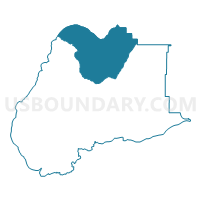
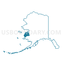
Kotlik Precinct, Wade Hampton Census Area, Alaska
About
Outline

Summary
| Unique Area Identifier | 523546 |
| Name | Kotlik Precinct |
| County | Wade Hampton Census Area |
| State | Alaska |
| Area (square miles) | 3,024.40 |
| Land Area (square miles) | 2,645.67 |
| Water Area (square miles) | 378.73 |
| % of Land Area | 87.48 |
| % of Water Area | 12.52 |
| Latitude of the Internal Point | 62.84789040 |
| Longtitude of the Internal Point | -163.55820390 |
Maps

Graphs
Select a template below for downloading or customizing gragh for Kotlik Precinct, Wade Hampton Census Area, Alaska


Neighbors
Neighoring Voting District (by Name) Neighboring Voting District on the Map
- Emmonak Precinct, Wade Hampton Census Area, AK
- Mountain Village Precinct, Wade Hampton Census Area, AK
- St. Mary's Precinct, Wade Hampton Census Area, AK
- St. Michael Precinct, Nome Census Area, AK
Top 10 Neighboring County Subdivision (by Population) Neighboring County Subdivision on the Map
- Nome census subarea, Nome Census Area, AK (9,492)
- Wade Hampton census subarea, Wade Hampton Census Area, AK (7,459)